.jpg)
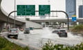
Fraudsters beware – a fleet of satellites is out to foil unscrupulous individuals’ plans to profit from natural disasters through excessive disaster insurance claims.
Planet, a San Francisco-based company, has sent around 380 satellites into space. These satellites can take high-resolution photos of the Earth’s surface, catching any significant change. According to Planet’s executives, the satellites can also help detect insurance fraud.
The company has over 175 “Planetscope” satellites operational, which can take photographs at a resolution of three metres per pixel. Meanwhile, its “Skysat” satellites can take even more accurate photos, with a 0.8-metre per pixel resolution. These satellites can verify whether a building has indeed burned down, or whether a specific property was damaged by floods.
“These satellites are continuous, and they tell the truth,” Andrew Zolli, vice president of global impact initiatives at Planet, told Pacific Standard. “What we see coming is a world in which the combination of very sophisticated analysis and continuous data feeds allows people to take some categories of fraud and make them so difficult to perpetrate that they cease altogether.”
Profiting from disaster insurance is easy nowadays, given the large amounts of funds being disbursed and the need for immediate pay-outs making it hard for insurers or government agencies to monitor claims.
While disaster insurance fraud may seem like a victimless crime, it deprives limited resources from those who were actually affected by the disasters.
In order to assist human users of satellite images, Planet is helping develop artificial intelligence-powered programs that analyse images and automatically report any significant changes detected. The satellite images before and after a disaster can also help insurers and law enforcement agencies to identify which claimants are lying and which are telling the truth.
In India, Cloud to Street, a start-up that conducts flood modelling using data from Planet’s satellites, has developed a scheme that automatically identifies the presence of floodwaters. The firm says that the index has already been completed, and that it hopes to apply it in cooperation with an insurer during the next monsoon season.
“There are shopkeepers and smallholder farmers who, in many cases, are living on the edge of poverty,” said Bessie Schwarz, Cloud to Street’s co-founder. “When floods hit, they take their kids out of school and sell off critical assets so they can still afford medicine, still afford to eat during monsoon season. The satellite imagery can detect that potentially as it’s happening, or near real-time, and then do those payouts very quickly, so we can provide that capital to people there.”