“This came from a real life scenario,” said Ken Tolson (pictured above).
Tolson is CEO of digital solutions for Crawford & Company, one of the world’s largest claims management providers. He was explaining how insurers and reinsurers typically use data from three different sources to accurately assess property damage after a natural disaster - and also to predict costs before an event happens.
“We were working with a reinsurer that has spent quite a bit of effort developing a solution to use satellite technology to provide an assessment to carriers to look at an event and try to assess reserving and get to a point of getting very accurate about what the impact will be,” said the 30-year industry veteran.
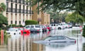
The three sources are satellite data, aerial photography and evidence from on-the-ground inspection. Tolson said pooling this trio of inputs significantly improves the accuracy of property damage assessments after nat cats.
“You can see from a reinsurance standpoint, that’s important, because once a storm gets over a certain dollar amount it becomes a reinsurer challenge,” he said. “It’s in their best interest to have the best information possible as quickly as possible on an event.”
Tolson said Crawford helped this reinsurer pool all this damage information.
“We were working with them to take the [satellite] analysis they did from 100 miles above the Earth,” he said. “Then look at it from lower levels with aerial pictometry taken from airplanes and then also the traditional way of literally driving somebody out to the property to take photos from either in the structure, around the structure or inside it.”
This allowed a comparison between different data sources, he said, and a way of checking any assumptions.
“It could all be pooled together to inform a data model to get more accurate with the reserving,” said Tolson. “That’s the role we played on the ground, to supply that ground truth to that sky view model.”
The CEO said this can help avoid errors worth millions of dollars.
“This [trio of inputs] helps them inform the model because there are assumptions in that model when they look at that image, and the algorithm spits out $2 million, or a billion dollars’ worth of damage,” said Tolson. “The better the data, the better imagery you have, the better assumptions you make about that image-change, the better your accuracy is going to be.”
Aside from accuracy, Tolson said a major driver today for his firm and carrier partners is the need for speed.
“What we’re always searching for is to speed up,” he said. “To drive the best customer experience after a catastrophic situation is to get people restored as quickly as possible.”
Tolson said this speed factor is front and centre.
“It’s really about how we pool these solutions together to accelerate the claims process, the adjudication process and get funds flowing - and not just funds flowing back into an area but also the restoration effort as well,” he said.
In the coming years, Tolson expects to see more sharing of publicly accessible nat cat data.
“You will see more of that,” he said. “Governments will continue to get better at distributing this information to the people who can really act on it the fastest, then those downstream providers will get faster at acting on it.”
Tolson also said satellites can play a particularly effective role in prevention.
“I think the insights into what we can do with that technology, to be more preventative, is what satellites will be able to provide,” he said.
The CEO said this could include being better prepared and able to react more quickly to wildfires.
“I think that’s where satellite technology plays a big role, in the pre-loss preventative aspects,” said Tolson. “It’ll always play a role in post-loss but the real investment, I think, that’s taking place, is about how to prevent and mitigate loss.”
According to online sources, ground truth is a term used in statistics and machine learning that refers to checking results for accuracy against the real world. However, it was originally a meteorological term for weather information obtained on a site.
How do you see the effectiveness of the different sources of data and information used by the industry to handle natural catastrophes? Please tell us below