The Natural Hazards Commission Toka Tū Ake (NHC) is drawing attention to new research that examines how earthquakes can alter river systems and increase flood risks in New Zealand.
The study – led by Erin McEwan, a PhD candidate at Te Whare Wānanga o Waitaha University of Canterbury – is the first to systematically catalogue the effects of seismic events on rivers and flood protection infrastructure.
Dr Natalie Balfour, head of research at NHC, said the research broadens the understanding of earthquake impacts.
“Damage from earthquakes isn’t just caused by shaking, which is why research that looks at the suite of related hazards is so important – it helps us understand the full picture of earthquake risk and gives decision-makers the science they need to plan ahead. From a planning perspective, knowing where flooding is more likely after a quake gives us a powerful new tool to protect people and properties, ” she said.
According to McEwan’s findings, more than 3,700 rivers in New Zealand could be exposed to increased flood risk if fault lines beneath them rupture. Of these, over 450 rivers are comparable in size to Canterbury’s Hororata River.
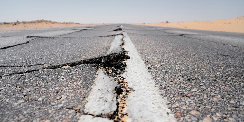
The research demonstrates that earthquakes can shift river channels, damage stop banks, and, in some cases, create new lakes or permanent dams. These changes can result in ongoing flood risks that persist well beyond the initial seismic event.
Historical events illustrate the scale of the hazard. The 1987 Edgecumbe earthquake caused significant damage to stop banks and lowered land in the Rangitaiki River floodplain. The region has since seen repeated flooding, including a major event in 2017 that required the evacuation of thousands of residents.
Other major earthquakes, such as those in Christchurch and Kaikōura, have also altered water movement and changed flood risk boundaries.
“This is a hazard that hasn’t had much attention before,” McEwan said. “But in New Zealand, where we have thousands of rivers and lots of active fault lines, it’s inevitable that they will intersect and interact.”
To develop the new database, McEwan and her team analysed 52 earthquakes worldwide where rivers were affected by fault ruptures.
The research incorporated global data, New Zealand’s fault maps, and flood modelling techniques to simulate future scenarios and identify areas most at risk.
“It’s a very real hazard that we see again and again after large earthquakes,” McEwan said. “This research gives us tools to start predicting where those risks might be highest.”
McEwan noted that the approach could support more resilient flood risk mitigation across the country.
“We can’t stop earthquakes or floods – but we can help people be ready for them. My goal is to get this into the hands of councils and planners so they can run their own ‘what if’ scenarios and make smart decisions for their communities,” she said.
The findings suggest that careful consideration is needed when planning new developments near fault lines and flood-prone areas, and that this research could inform future land use and infrastructure decisions.
The release of this research comes as new analysis commissioned by IAG New Zealand estimates that the country has spent approximately $64 billion on natural disaster response since 2010. Most of this expenditure has been directed toward recovery, with less allocated to prevention.
The analysis found that central government allocated $19 billion to disaster response over the past 15 years, with an additional $14 billion distributed through public insurance mechanisms.
Private insurers accounted for $31 billion, bringing the total to $64 billion, or about $5.5 billion per year in inflation-adjusted terms. Government contributions represent roughly half of this total.