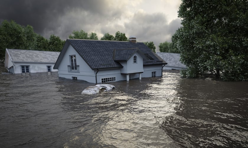
Tasman District Council expects recovery from last year’s back-to-back flood events to cost about $50 million and to take up to two years, reflecting the scale of physical damage and insurance exposure in one of New Zealand’s most flood-affected regions.
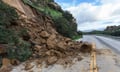
Record rainfall in June and July triggered what local authorities described as the worst flooding in the district in more than a century, affecting farms, rural communities, transport links, and river protection assets. More than 60 roads were closed at the height of the event because of flooding, landslips, and fallen trees, and hundreds of homes required building assessments. Of those, 36 properties were yellow-stickered and five red-stickered.
According to RNZ’s report, Nelson Tasman Emergency Management Group recovery manager Richard Kirby put the direct repair bill at about $48 million, with roughly three-quarters expected to be covered by a mix of insurance claims and central government support, leaving close to $12 million to be funded by the council. Damage to river infrastructure is estimated at between $23 million and $25 million, while roading losses are just over $20 million. The cost to private landowners has yet to be fully quantified. Industry data from the Insurance Council of New Zealand (ICNZ) show 2,807 claims totalling $37.4 million from the June South Island floods, bringing the total event cost close to $100 million across public and private assets.
The Tasman recovery effort is taking place as local government flood management is subject to closer review. A report from the Office of the Auditor-General, tabled in Parliament in December, concluded that councils need to strengthen preparedness for flooding and improve how they manage related risks to communities. The report examined Tasman District’s approach to flood protection infrastructure and found weaknesses in the council’s understanding of the condition of its assets and the absence of a regular inspection schedule. It recommended that the council develop a structured framework to prioritise maintenance and capital works for stopbanks and other flood defences, supported by stronger asset management processes.
Kirby said the council’s information on river assets and protection works had been incomplete, an issue now being addressed as part of the recovery and future risk planning. He described the existing system as a “compromised database” and said the council was updating records for ongoing monitoring, maintenance and insurance purposes. “If you don’t do that upfront planning and investment, then you end up with problems later, and I think to a certain degree, we’re in that space where we probably haven’t done sufficient monitoring and planning in the past,” Kirby said, as reported by RNZ.
Several rivers in the region reached record levels during the storms, with the Motueka River downstream of Tapawera and the Wai-iti River south of Belgrove among the most affected channels. The flooding damaged banks, river control works, and adjoining land, creating future erosion and inundation risks if not reinstated. Kirby said the council’s rivers team had completed a network-wide assessment and set priorities for areas considered most exposed in subsequent storms. Around $6 million has been spent so far on river works. “They’ve identified the areas that are less resilient, and they’re working their way through them on a priority basis so that should we have another [flood] event, the critical areas would have been fixed before next summer,” Kirby said.
Read next: Can Kiwis keep home insurance beyond 2035?
The programme includes rebuilding sections of stopbanks, as well as in-river initiatives such as rock armouring to stabilise banks and reduce the likelihood of future channel movement. Kirby said the timeframe to re-establish control over the river network is likely to be 18 months to two years, assuming there is no further major event that reverses progress. “I think at least it’s probably heading up towards 18 months, maybe two years before we get on top of it and of course, that’s hoping that we don’t have another event over that period of time to undo what we’re trying to do,” Kirby said.
The district’s roading network remains another significant area of cost for both public funders and insurers. Since the storms, about 4,500 individual roading jobs have been logged, with roughly 1,000 still to be completed. Kirby said close to 30 people are working on repairs each day. Multiple slips on State Highway 60 over Tākaka Hill reduced the route to a single lane at several points, with six heavily damaged sections needing major works.
Waka Kotahi NZ Transport Agency system manager for Nelson-Tasman Rob Service said the works programme involved rebuilding and strengthening sections of the highway, addressing erosion risks, improving drainage, and stabilising the underlying ground conditions. The highway was restored to two-lane operation before Christmas. Four local roads remain closed: Haycock Road, Quail Valley Road, Gannet Heights, and Graham Valley South Branch Road. Graham Valley South Branch Road, which provides access to Kahurangi National Park, has been shut since a major section was undercut by the Graham River. The road is managed by the Department of Conservation (DOC), supported by the council.
DOC Motueka operations manager Chris Golding said planning is underway to reopen access to the Flora car park, the main entry point for several of the park’s alpine walks, with works expected to commence in early 2026. Costs will be shared between Tasman District Council, DOC, and Waka Kotahi. For now, the road remains closed to vehicles and the public is being asked not to cross the affected area. Residents on the far side of the slip can leave on foot, but road access is restricted.
For rural policyholders and their insurers, the recovery has been operationally and financially complex. Top of the South Rural Support Trust chair Richard Kempthorne said the trust had spoken with around 220 farmers, many with land adjacent to rivers and waterways where gravel, silt, and flood debris have accumulated, fences have been destroyed, and areas of productive land have been lost to erosion. He said the Enhanced Task Force Green programme, run by the Ministry of Social Development, has provided two teams of nine workers over a six-month period to support on-farm clean-up.
Kempthorne added that some landowners have been unsure about what flood recovery works they can undertake on their properties without formal consent and which interventions require regulatory approval. Others are weighing whether they need to change how they use land or assets in order to manage future events.
The Tasman events are occurring against a broader national backdrop of increasing flood exposure. Recent nationwide research led by Earth Sciences New Zealand estimates that more than 750,000 people currently live in areas at risk from one-in-100-year rainfall-driven flooding. Under a scenario where New Zealand experiences an additional 3 degrees of warming, that number could rise above 900,000.
The same research puts the value of building assets exposed to such events at about $235 billion today, rising to around $288 billion under the higher warming scenario. Infrastructure exposure is also significant, with an estimated 26,800 kilometres of roads, 14,100 kilometres of stormwater pipelines, and 21% of national grid sites currently located in flood-prone areas. Under further warming, these figures could increase to 30,800 kilometres of roads, 15,400 kilometres of stormwater lines, and 29% of grid sites.
For insurers, reinsurers, and brokers, the Tasman recovery illustrates how localised events intersect with this wider risk profile, underscoring the role of detailed asset data, flood-resistant design, updated land-use decisions, and defined funding arrangements between central government, councils, infrastructure owners, and private landholders.