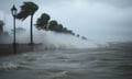
Gale-force winds and towering swells struck Wellington on Tuesday, pushing authorities to declare a state of emergency, order coastal residents to leave their homes, and shut down key transport links connecting the North and South Islands.
According to 1News, Mayor Andrew Little declared a state of emergency covering Wellington’s Southern and Eastern wards on Monday afternoon, hours before the worst of the weather was expected to arrive. The Wellington City Council followed with mandatory evacuation orders for waterfront properties in Owhiro Bay, Island Bay, Houghton Bay, and Breaker Bay, with residents and their pets required to be clear of affected properties by 9am Tuesday. Lyall Bay was excluded from the order.
Wellington Civil Defence Controller Phil Becker said the projected wave sizes created a genuine threat to people living on the coast, with seawater inundation of properties considered a realistic outcome. Wellington Regional Emergency Management said conditions could rank among the most severe the region has experienced in recent years and urged residents to relocate valuables from low-lying areas, assemble emergency supplies, and establish contingency plans ahead of the peak swell period. “If your property has been affected by previous swell events, now is the time to prepare,” the agency said, as reported by 1News. The council identified two high-risk windows tied to high tide: 9:19am to 1:19pm Tuesday and 9:42pm Tuesday through 1:42am Wednesday. For those without somewhere to go, the council opened an Emergency Assistance Centre at Wellington South Baptist Church from 9pm Monday.
MetService meteorologist Devlin Lynden said the storm was being driven by a deep low-pressure system anchored south of New Zealand, pushing strong south-westerly winds over a wide stretch of open water. “There’s a deep troughing to the south of the country – a deep low pressure system – which is driving very strong south-westerly winds in the area,” Lynden told 1News. Two converging factors were responsible for the scale of the swell: the strength of the wind and the fetch – the uninterrupted distance across which wave energy had been accumulating. With the Southern Ocean providing virtually no barriers, the swell had built over an enormous distance before reaching New Zealand’s coastline. “The combination of large fetch and strong winds is what’s creating these significant swells,” Lynden said.
Wave heights along Wellington’s coastline from Cape Terawhiti to Turakirae Head were forecast at 7 metres to 8 metres around midday Tuesday. Further along the Wairarapa coast, from Turakirae Head to Mataikona, combined waves of 9 metres to 10 metres were expected during the late morning. Hazardous conditions were also forecast for the Chatham Islands, the southern Kaikōura coast, parts of Banks Peninsula, and the Catlins coastline south of Dunedin. Lynden flagged the pace of change as a particular concern for residents and marine operators. “We are talking about rapidly rising, which is not a wording we use commonly, and it really reflects how quickly the swells are likely to rise in the affected areas,” Lynden said. Recreational boaters were urged to avoid harbour entrances and bar crossings, where large swells significantly raise the level of risk.
The storm severed the main transport corridor between the North and South Islands. Interislander cancelled all of its Tuesday sailings, while Bluebridge pulled its 8:30pm Monday Wellington-to-Picton departure and three Tuesday morning services. Both operators confirmed that affected passengers were being moved to the next available sailings, according to 1News. Wellington Airport also saw the cancellation of approximately eight flights. Air New Zealand advised passengers that high winds could affect departures from Wellington and made rebooking options available, South China Morning Post reported. On the ground at the airport, a light aircraft was knocked onto its wing and wheel by a wind gust shortly after landing and disembarking its passengers. The airport confirmed in an email that no one was hurt and the aircraft was returned to its normal position without delay. Road closures across Wellington’s south coast added to the disruption, with the council warning residents to expect extensive restrictions through the course of Tuesday.
As the storm unfolded, the Insurance Council of New Zealand (ICNZ) was separately calling on political parties to replace the current Fire and Emergency New Zealand (FENZ) levy with a Community Protection Levy – a mechanism designed to channel funding into hazard risk reduction before disasters occur. ICNZ chief executive Kris Faafoi said the existing levy structure has not kept pace with the country’s evolving risk profile. “The current levy is too complex, too uneven, and no longer well suited to the risks New Zealand faces today,” Faafoi said.
The proposal would shift FENZ from insurance-linked levies to Crown funding, with an estimated $600 million to $700 million per year redirected toward resilience projects. The new levy would be collected by insurers on behalf of the government. Faafoi cited the $4 million Taradale stopbank, which helped shield communities during Cyclone Gabrielle, and the $15 million Awanui Flood Protection Scheme in Kaitaia – estimated to have prevented around $50 million in damage – as cases where early investment had delivered measurable results. “We cannot keep spending more on disaster recovery while underinvesting in prevention,” Faafoi said.