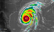
Hurricane Isaias is forecast to make landfall along the northern Gulf Coast late Friday or early Saturday as a significant hurricane, ending more than two years without a US hurricane landfall. The National Hurricane Center (NHC) has issued hurricane warnings for coastal Mississippi, coastal Alabama, and the western Florida Panhandle, with storm surge watches across the same zone. States of emergency have been declared in 25 Florida counties and 40 Alabama counties.
Phil Klotzbach, a senior research scientist at Colorado State University and non-resident scholar at the Insurance Information Institute (Triple-I), said Isaias is forecast to peak at 110 mph winds before encountering vertical wind shear as it approaches the coast. Even with some weakening, he said, Isaias is still likely to be a significant hurricane at landfall. The NHC warns of storm surge up to seven feet, rainfall totaling up to 15 inches in some areas, flash flooding, and a risk of tornado outbreaks extending through the weekend.
Moody’s data estimates that 31,659 commercial properties across Alabama, Florida, and Mississippi have a greater than 50% probability of facing winds of at least 50 mph — the threshold at which some structural damage becomes likely. Their combined estimated value is $71.8 billion. Among those, 14,945 are multi-family residential buildings valued at approximately $40.2 billion. The cities most exposed include Mobile, Alabama; Pensacola, Florida; and Biloxi, Mississippi.
James Cosgrove, associate director of event response at Moody’s, said Isaias is tracking similarly to Hurricane Sally in both landfall location and forecast intensity. Sally made landfall near Gulf Shores, Alabama in September 2020 as a Category 2 storm and generated approximately $2 billion in privately insured losses, according to Karen Clark & Company - a figure that excluded National Flood Insurance Program (NFIP) losses, which added hundreds of millions more. Moody’s will publish loss and damage estimates after Isaias passes.
The storm’s arrival as a named hurricane activates policy mechanics that can catch commercial clients off guard, particularly those whose policies have not been tested against an actual loss since before last year’s quiet season. Wind damage to structures is covered in some commercial property policies (though in some it may be placed through state wind pools), but flood and storm surge - which drove a significant portion of Sally’s losses - require separate coverage, either through the NFIP or a private insurer.
Hurricane deductibles add a separate layer. In coastal states, these are typically calculated as a percentage of total insured value rather than a flat dollar amount, and they are triggered by named-storm designation. A 5% hurricane deductible on a $5 million commercial property means the policyholder bears the first $250,000 of loss before coverage responds - a figure that surprises clients who assumed they had standard deductible terms.
Business interruption coverage warrants a separate check. The standard trigger requires direct physical damage to the insured property, meaning clients displaced by mandatory evacuations or power outages without structural damage may find the base form does not respond. Many commercial property policies include civil authority and utility service interruption extensions that can cover those scenarios, but both carry their own triggers, waiting periods, and sublimits that vary by form - clients should confirm what they have before the storm makes those terms academic.
Triple-I advises those in the storm’s path to confirm insurer and broker contact details, document property conditions before the storm, secure outdoor equipment, and follow evacuation orders from local authorities.