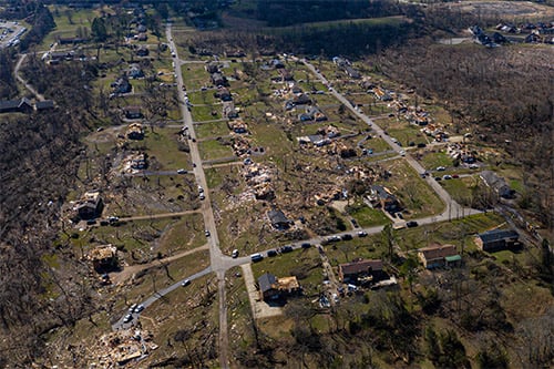
The Geospatial Intelligence Center (GIC) has collected high-resolution aerial photographs of damaged structures following a series of Easter weekend tornadoes that struck multiple states – and these photos have been made available for insurers to use.
GIC took photos of the communities hit the hardest by the tornadoes, which included portions of Chattanooga, TN, Monroe, LA, and Seneca, SC. The images are now available to GIC members, a release said.
A company release added that these high-resolution aerial images provide insurers with “vital information” to better serve policyholders, expedite the claims resolution process, and even help with fraudulent claim detection. GIC imagery is also being offered at no cost to emergency personnel, first responders, and law enforcement.
“Post-catastrophe damage assessment is crucial to recovery efforts following devastating tornadoes and other events like these. Impacted areas need to be assessed to ascertain how many structures have been damaged or completely destroyed,” said GIC director of catastrophe response Richard Butgereit. “It is our hope that by getting in quickly and assessing these efforts utilizing high-resolution aerial imagery, we can help speed up the recovery process for those affected by these events.”
“Technological advances have improved in recent years, providing insurers the opportunity to leverage cutting edge technologies like the high-resolution imagery provided by the GIC to enhance fraud detection and expedite fraud investigations,” commented National Insurance Crime Bureau (NICB) chief operating officer Jim Schweitzer. “The GIC program is just another example of how the industry is leveraging innovation to help fight fraud in the wake of a disaster.”
The NICB helped develop the GIC as a solution to support both its insurer members and law enforcement. GIC licenses high resolution aerial images from Vexcel Imaging US.